Geolocation Settings
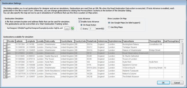
The Geolocation Settings dialog (screenshot below) enables you to specify geolocations from an XML file for designer and server simulations. You need to specify geolocations in this way because these simulations do not use a mobile device and therefore have no geolocation data available to them. These geolocations stand in for the actual geolocations of a mobile device.
The Geolocation Settings dialog is accessed via the Simulator dialog:
1.Click Run | Simulate Workflow (F5) or Run | Use Server for Workflow Simulation (Ctrl+F5) to access the Simulator dialog.
2.In the Simulator dialog, click the Geolocation button at bottom left to open the Geolocation Settings dialog (screenshot below). The settings made here will be used for both designer and server simulations.
Note: If no geolocation action is used in the design, the Geolocation button will be not be displayed in the Simulator dialog.
The geolocation settings
You can make the following geolocation settings:
•Geolocation XML file: Contains the default geolocations to use for simulations. The XML file must have the structure listed below. The Browse button enables you to browse for the file. The Refresh button enters the geolocation data of the XML file into the available geolocation values pane in the lower part of the dialog. The default file can be overridden by a geolocations simulation file that is specified in the Start Geolocation Tracking action.
•Auto Advance: If Auto Advance is enabled, each geolocation in the XML file is read in turn during simulation. You can specify the time interval between the reading of each geolocation. If Auto Advance is not specified, you can change geolocations during simulation by clicking the Previous or Next buttons at the bottom left of the Simulator dialog. Note that these geolocation values run in the simulator only. They are passed to page source tree nodes (including the $GEOLOCTION tree) only when such an action is explicitly specified in the design.
•Show Location on Map: Selects which map application to open in the web browser when the Show Geolocation on Map action is executed.

The geolocation XML file structure
In order for MobileTogether Designer to correctly read geolocation data, the geolocation XML file must have a structure similar to that shown in the listing below. Attributes may be omitted or their values may be the empty string. However, the //Location/Latitude and //Location/Longitude attributes need to be present
This example shows one Geolocation element expanded. Not all attributes of the Location and Address elements are used. For a complete list of attributes, see the next listing. For the lexical format of latitude and longitude values, see the section Geolocation Input String Formats below.
<Root> <Geolocations><Geolocation name="Buckingham Palace"><LocationLatitude="51.501364"Longitude="-0.14189"Provider="gps"/> <Address |
<Root> <Geolocations><Geolocation name=""> <Location AccuracyHorizontal="" AccuracyVertical="" Altitude="" Latitude="" Longitude="" MagneticHeading="" Provider="" Speed="" Time="" /> <Address AdminArea="" CountryCode="" CountryName="" FeatureName="" Locality="" Phone="" PostalCode="" Premises="" SubAdminArea="" SubLocality="" SubThoroughfare="" Thoroughfare="" Url=""> <AddressLine/> ... AddressLine* elements ... <AddressLine/> </Geolocation> </Geolocations> </Root>
|
The geolocation input string must contain latitude and longitude (in that order) separated by whitespace. Each can be in any of the following formats. Combinations are allowed. So latitude can be in one format and longitude can be in another. Latitude values range from +90 to -90 (N to S). Longitude values range from +180 to -180 (E to W).
Note: If single quotes or double quotes are used to delimit the input string argument, this will create a mismatch with the single quotes or double quotes that are used, respectively, to indicate minute-values and second-values. In such cases, the quotes that are used for indicating minute-values and second-values must be escaped by doubling them. In the examples in this section, quotes used to delimit the input string are highlighted in yellow (") while unit indicators that are escaped are highlighted in blue ("").
•Degrees, minutes, decimal seconds, with suffixed orientation (N/S, E/W) Example: 33°55'11.11"N 22°44'55.25"W
•Degrees, minutes, decimal seconds, with prefixed sign (+/-); the plus sign for (N/E) is optional Example: 33°55'11.11" -22°44'55.25"
•Degrees, decimal minutes, with suffixed orientation (N/S, E/W) Example: 33°55.55'N 22°44.44'W
•Degrees, decimal minutes, with prefixed sign (+/-); the plus sign for (N/E) is optional Example: +33°55.55' -22°44.44'
•Decimal degrees, with suffixed orientation (N/S, E/W) Example: 33.33N 22.22W
•Decimal degrees, with prefixed sign (+/-); the plus sign for (N/S E/W) is optional Example: 33.33 -22.22
Examples of format-combinations:33.33N -22°44'55.25" 33.33 22°44'55.25"W 33.33 22.45 |

